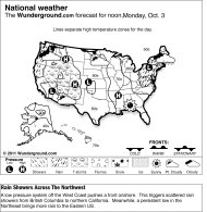
The central United States will see a warming trend, while the West remains rainy and snowy on Sunday.
A low pressure system off the coast of southern California will advance onshore, moving over the Southwest. Counter-clockwise flow around this system will continue pulling moisture onshore, allowing for rain and high elevation snow showers to persist across the Southwest.
To the north, a low pressure area over the northern Rocky Mountains will extend southward into the central Rockies. This will bring heavy snow showers to Utah and Colorado, while snowfall will decrease across Idaho and Montana. Winter weather advisories have been issued across the Central Rockies, as 3 to 7 inches of snow are expected, with up to a foot at highest elevations. Blizzard warnings are in effect for Colorado due to wind gusts ranging between 50 and 60 mph, causing blowing snow and low visibility. Idaho, Montana, and Wyoming will see another 2 to 4 inches of snowfall on Sunday.
In the Northwest, another trough of low pressure will approach Washington and Oregon. This is expected to bring more rain showers and high elevation snow to the Cascades.
In the Plains, a trough will advance over the Northern Plains and into the Upper Midwest and Great Lakes, triggering widespread scattered rain showers. Flow ahead of this system will push warm air in from the South, allowing for high temperatures to range 10 to 15 degrees above seasonable. The back side of this system will pull cool air in from Canada, allowing for rain showers to turn to snow showers across the Dakotas and northern Minnesota.
Temperatures in the lower 48 states ranged Saturday from a morning low of 8 degrees at Mt. Washington, N.H., to a high of 84 degrees at McAllen, Texas.


 العرض العادي
