Valid from 10/02 to 05/03 2012
Cold much of February
Issued: Saturday 4th February 2012
Duty forecaster: Simon Keeling & Captain Bob
Winter has thrown down its heavy cloak on whit upon the Continent; it may be a while before it is removed?
The winter forecast has been premised upon the idea that although 'late', the winter would have a notable 'sting', I believe this has may have been vindicated at least in part, much of Europe suffering much worse than here in the UK.
The anticyclonic block responsible for the wintry weather appears to be holding at least in the short to medium term, thereafter there appears to be indications that it'll reposition to the north or northwest, keeping the conditions here in the UK and the cold and at times unsettled 'bag'?
I have a feeling that this rather cold and wintry spell may extend well into the latter stages of February before relenting in early March.
*.......10/02/12*
High pressure looks as if it'll be holding fast to the east through the period maintaining the rather cold and wintry feel to the conditions feeding a continentally sourced air mass through all areas of the UK.
Cold and frosty overnight with some freezing fog patches too, clearing to a crisp cold sunny day, lingering in prone areas with low cloud and a raw feel to the day. Not entirely dry beneath this anticyclonically influenced regime, some wintry showers appearing along exposed eastern coasts and always the threat of enhanced showery activity should lines of showers run through on an easterly drift.
*12/02/12 - 18/02/12*
It is here where I believe the anticyclonic block is removed from the east but relocated closer to the UK perhaps to the northeast or north, destabilising the general and overall pattern into one orientated from the northwest or north, still with the balance swung into the wintry ballpark? Showers or longer spells of unsettled weather, sleet and snow for many, rain fo western areas, the chill accentuated by the strength of the wind too.
*19/02/12 - 25/02/12*
High pressure reasserts here and one final spell of rather settled and quite wintry conditions falls over the UK, a large anticyclone drifting slowly south-easterly from the north or northwest. There'll be a return of frosts and fog to all areas during the overnight period. Clearing into pleasantly sunny days, perhaps feeling a little 'warmer' given stronger late winter sunshine and light winds?
As the high slips southeast into the near Continent, a light southwesterly flow may establish firstly across northwestern Britain then remaining areas as the month comes to a close, becoming less cold later with increasing cloud ahead of patchy rain through western Britain.
*26/02/12 -05/03/12*
High pressure remains a large feature to the southeast of the UK, however with a southerly drift establishing across all areas temperatures will be recovering gradually, a modified Mediterranean sourced flow establishing. Pleasantly sunny in most areas with perhaps the signs of spring warmth at last being noted.?
هذه النشرة الشهرية للموقع Weatheronline.uk , وأهم ما يشير له هو المخطط بالأحمر .. في الفترة الممتدة من 26/2/2012 الى 5/3/2012 ..
حيث تشير هذه التوقعات على وجود ضفط مرتفع فوق غرب أوروبا على المملكة المنحدة ( United Kingdom ) وسيطرة المرتفعات الجوّية على تلك المناطق المحيطة أيضأ .
وبدأ مبكّر للربيع في تلك المناطق .. وسيطرة للأوزوري على تلك المناطق ..
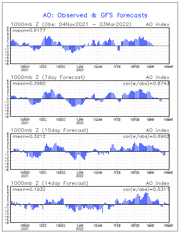
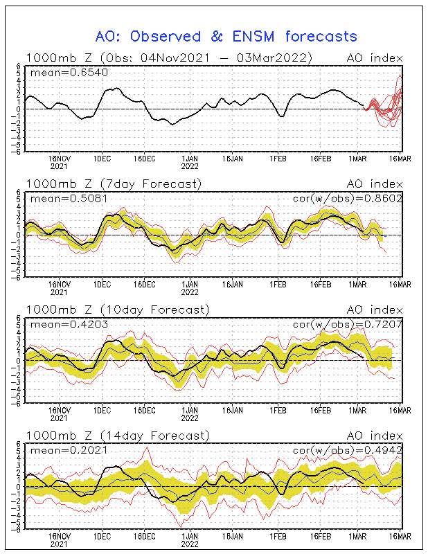
ونضيف على ذلك إيجابية التذبذب القطبي ( AO+) وبقيم ممتازة ولا أتوقع أن تكون بهذه القوة الذي يتوقعها النموذج الأميركي :
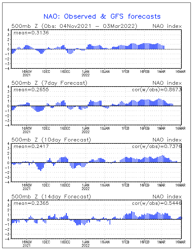
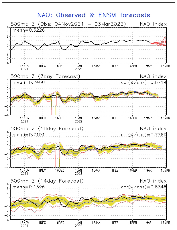
وكذلك شمال المحيط الأطلسي ( Nao ) بقيم أيضاً إيجابية ممتازة والحمد لله :
==================
منطقة الشرق الأوسط لن تشهد إستقرار على الفعاليات الجويّة وحالات عدم الإستقرار إلا أيام معدودة بإذن الله والحالات التي ستكون غالباً ( باردة جدّاً )
وذلك ما بدأ منذ يومين يلمّح له النوذج الأميركي (Gfs) والنموذج الأوروبي (ECMWF) وباقي أغلب النماذج ..
الحمد لله وهذه الإشارات التي أدعم بها قولي بأن :-
سينتهي هذا الموسم بإذن الله بكميات أمطار أعلى من المعدل ..
ودرجات الحرارة أدنى من المعدّل ..
لنتابع ونرى فضل الله علينا .. اللهم أنك عزيز كريم ..
والله أعلى وأعلم .
تحيــــــــــاتي


 = 650) this.width = 650; return false;">
 = 650) this.width = 650; return false;">
 = 650) this.width = 650; return false;">
 = 650) this.width = 650; return false;">
 = 650) this.width = 650; return false;">
 = 650) this.width = 650; return false;">
 = 650) this.width = 650; return false;">
 = 650) this.width = 650; return false;">
 = 650) this.width = 650; return false;">
 = 650) this.width = 650; return false;">
 = 650) this.width = 650; return false;">
 = 650) this.width = 650; return false;">


 العرض العادي
